I kayaked the Cape Fear River beginning on its tributary, Blounts Creek, shortly after Hurricane Matthew brought 14 inches of rain to the area in 18 hours. This came after the area got 8″ of rain from Tropical Storm Julia just 9 days prior.
I initially launched on 10/9/16, the day after the rain, reaching Campbellton Landing on the Cape Fear River that evening. I took out and returned the next day to paddle from there to the bridge that carries I-95 across the Cape Fear.
This extreme rain event on Saturday, 10/8/16, breached the Lake Walter Dam, which formed a substantial lake upstream on Blounts Creek. Details are here. Blounts Creek crested (at my house, 0.5 km below this dam) at about 3 pm Saturday at about 500 cfm.
In addition to being a kayaking narrative, this blog provides a local-water-shed cross-sectional-examination of the effects of Hurricane Matthew in Fayetteville NC.
——————————————————————————
I launched into Blounts Creek about 24 hours after it crested . Perhaps 50 cfm of water flow. This is a flow level at which I’ve run this creek previously about 5 times. It would have been foolish (and perhaps very dangerous) to have launched on Saturday.
I have Class V White Water skills – which makes it possible to paddle Class II Urban Storm Runoff with a comfortable safety margin. This is not an endeavor to be undertaken lightly. While the hydraulic challenges are class II, the level of skill required to do this safely is far higher. There is jagged broken concrete – with steel rebar sticking out. There are potentially hazardous germs – the Fayetteville Public Works Commission (PWC) routes various sanitary sewer lines along Blounts Creek, and they seem to leak. Potentially hazardous germs are also in the suburban runoff that accounts for a majority of high level flow. And trash, lots of it! And an occasional dead body.
Photos follow.
——————————————————————————

I put in at the bridge that carries Whitfield St. across Blounts Creek, seen here from downstream. Photograph taken 10/10/16.
Blounts Creek normally flows into Cross Creek about 2 km below this bridge, and normally, Cross Creek flows into the Cape Fear River after another 1 km.
It appears that lots of water flowed across the top of this dam on Saturday.
——————————————————————————

I parked here below the bridge. Note the erosion hole where water is standing in front of my car. There is an intact sheet of asphalt against the weeds at the lower left corner of this photo that appears to have been carried by water from where the erosion hole is now.

This erosion hole photographed from below on 10/10.
——————————————————————————

Blounts Creek passes through a culvert below this railway 0.2 km downstream from the Whitfield Bridge. It is a fun culvert to kayak through at this level – about 12 meters long, with a 0.8 meter drop into a pool at the end.
I believe that perhaps the limited flow capacity of this culvert caused big problems on Saturday: the washout of the railway (and perhaps for Robison St. to be under several feet of water Saturday at its intersection with the MLK Freeway).
——————————————————————————

A portage around logs required 0.4 km below Whitfield Bridge, at a site where I once experimented in the collaboration with homeless people in the construction of a permaculture farm.
Beneath the partially burned two-by-four rafter once used to form the ridge of a canvas shelter, you can see part of the washed out railway on the opposite side of Blounts Creek.
——————————————————————————
Another view of this damaged railway (taken 10/10/16), looking east.
This is the Rockfish & Aberdeen Railroad railway to Aberdeen – a track that was slated 6 years ago to carry 10 train loads of corn a day from the Midwest to Clean Burn Fuels’ ethanol plant in Raeford. On 10/10, I saw an assemblage of equipment and material (100s of cubic yards of sand) that I expect will be used for its repair.
——————————————————————————

My Eskimo Topo kayak – parked upstream of a mandatory portage. Amazed to not see any speck of Anthropogenic Trash! Matthew’s gifts were not all bad.
——————————————————————————

Here is what I found at the entrance to a tunnel beneath the Gillespie St. Bridge. Very similar to what I saw when I last kayaked under it about 3 years ago.
——————————————————————————
Surprised by what I found on top on the downstream side of this bridge!

——————————————————————————

Looking back at this bridge from downstream. It is not apparent what happened here hydrologically. I would like to see what it looked like on Saturday!
——————————————————————————

Here is what I found as I approached the Cool Spring St. Bridge – definite problems!
Time to portage – for about the tenth time!
——————————————————————————

Upstream side of this bridge.
——————————————————————————

Downstream side of this bridge.
——————————————————————————

Here is where I want to get back on Blounts Creek. How should this be done?
——————————————————————————

Beneath the Person St. bridge.
I’m standing with one foot on the sewage pipe you see. I had to get out of my kayak to get it over this pipe. There is a wooden chair stuck near the top of the space beneath the bridge! I expect that it floated into place on Saturday – and that a lot of water was then flowing under this bridge. Glad I wasn’t down here at that time!
——————————————————————————
While I was beneath the Person Bridge, I began to realize that the water level was getting quite high. And there was very little current. Have I perhaps reached the level of the Cape Fear River?

One of the railings of the bridge that normally carries Hawley Lane over Blounts Creek. – this hypothesis is looking very good.
——————————————————————————

Still water above what is normally the confluence of Blounts Creek and Cross Creek.
I’m now certain that I am in fact kayaking on the backed-up Cape Fear River! Thus, technically, Blounts Creek flowed straight into the Cape Fear today between Russel St. and Person St., bypassing Cross Creek (which was covered at the time by the Cape Fear)!
——————————————————————————

Looking south at the bridge that normally carries Grove Street over Cross Creek. Note the Cross Creek Linear Trail on the right (west), here partially submerged.
——————————————————————————

About 0.2 km below Grove Street. The only waves apparent here are from my kayak!
Looks like I can indeed expect flat water from here down, in fact, I am already down! I expect that he level at Campbellton Landing on the Cape Fear, where I plan to take out, about 2 km further , is not more than 6 inches lower than this.
——————————————————————————

Big problems with the Cross Creek Linear Trail below Grove St.
——————————————————————————

The bridge that carries North Eastern Blvd. over Cross Creek, looking east. The Cross Creek vistas I observed today remind me of vistas I observed canoeing as an undergraduate student on the km wide Suwannee River in Florida!
——————————————————————————

Cape Fear Botanical Garden. A river overlook deck is apparent. This deck is normally about 50 feet above Cross Creek. At this water level, it would be a good location for a boat pier!
——————————————————————————

This is fun! Kayaking amid the treetops – free to easily sprint over territory that is very rugged when dry.
——————————————————————————

Looking southwest at Sunset. Very clear, dry air; sucked in from Canada as Matthew departed yesterday.
——————————————————————————

And soon I’ll be floating above the normal confluence of Cross Creek and the Cape Fear River. How will I know when I’m there?
——————————————————————————
After another 300 meters, I emerge into a very broad opening. Is this the normal Cape Fear River bed? Yes it is – I see southward current developing as I proceed! I’m above the normal bed of the Cape Fear!
The Cape Fear crested at Fayetteville a few hours after I reached Campbellton Landing at 59 feet. It is normally 10 feet at this time of year. Flood stage begins at 35 feet.
——————————————————————————

Looking downstream at the Grove Street Bridge over the Cape Fear (1.5 km east of the Grove Street Bridge over Cross Creek where I photographed a partially submerged section of the Cross Creek Linear Trail).
I’m in about 3 MPH of current – no worries – I can paddle a kayak more than twice as fast.
——————————————————————————

Just below the Grove St. Bridge, now looking downstream at the Person Street Bridge over the Cape Fear (1.2 km east of the Person St. bridge over Blounts Creek where I photographed the stranded chair).
I used my non-water-proof Samsung Galaxy S4 phone on this trip (keep in a dry box when not in use). This reflects the fact that at this very high level, the Cape Fear at Fayetteville is essentially Class I Water!
——————————————————————————

At normal levels, the Cape Fear is Class II White Water, at least at the Continental Shelf at Erwin – navigable in practice in a water ski boat, see http://isely.info/WH//Merrill/Carol/John/Carolina_Voyaguer/.
——————————————————————————

Looking upstream at the east end of the Person Street Bridge.
——————————————————————————

Finally. I reach Campbellton Landing as it begins to get dark. About 40 feet of water to the base of that nearest lamp pole!
——————————————————————————
I then bicycled back to my car, picked up my boat, drove home, and started to assemble this blog.
——————————————————————————
I continued my journey downstream on Monday, 10/10/16, launching at about 6 pm at the Person St. Bridge on river right. The Cape Fear level was then 57-feet.
About 150 meters downstream of the Person St. Bridge is another asset of the Rockfish & Aberdeen Railroad, this distinctive railway bridge.

The R+AR Railway Bridge photographed from upstream looking SW with a 10-foot flow level.
When I skirted the upstream edge of this bridge on Sunday evening before taking off the river, the water was at the bottom of the white bridge structure.
——————————————————————————

Photographed at about the time I launched on 10/10/16, two days after Matthew. Taken from the Person Street Bridge, looking downstream at the R+AR Railway Bridge with the Cape Fear level at 57-feet on the USGS Gauge in Fayetteville. The white bridge structure began only two feet above the river! At normal flow level, this structure is 48 feet above the river, see previous photo!
Thus Hurricane Matthew made the Cape Fear a non-navigable river at Fayetteville.
——————————————————————————_________——–
I decided to go under the railway bridge.
With only two feet between the water and the bottom of the bridge structure, this is a decision that you may want me to explain…
OK, here is at least some context…
I’ve been on this section of this river many times over the last decade in a wide variety of boats, and have done many other things in this area.
——————————————————————————

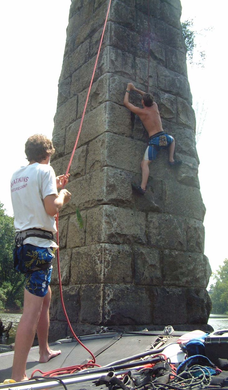
This photo shows Chris Mattox climbing the upstream edge of the west face of the stonework pier on river-left.
This was taken on 8/8/2008 at a normal flow level. Cousin Ludwig Schneider belays from the deck of my sail boat anchored just upstream of the bridge. Had he been there on 10/10/16, his head would have been 41 feet underwater, and Chris’ head, 33 feet deep!
——————————————————————————
Back to my decision to kayak below a railway bridge with only 2 feet of clearance above the water. This was a sensible decision only because I knew the structure of this bridge well. I have often climbed on its stone work support piers, see the previous photo. This involved connecting by rope to the bridge structure for top-roping. Thus I knew there no nasties (e.g., jagged metal) at the bottom of the bridge.
I once even did a pendulum jump there! We jumped off of the downstream side of the train track with a climbing harness and rope strung below the bridge, and tied on the upstream side. It was a safe, but jarring deceleration – pendulum jumps are better done on flatter bridges.
Also, there was only 3 MPH of current – so I could escape by paddling upstream if I changed my mind.
I got under it safely, but I ended up being out of my kayak!
The best way to do have done this would have been to deliberately capsize (flip) a few meters upstream of the bridge; wait 15 seconds to know that I have drifted well downstream of the bridge; then roll back to upright using the Eskimo Technique.
However, I decided to try to turn on my side to pass under the upstream edge; return to upright in the open space beneath; and then again turn on my side to pass under the downstream edge of the bridge.
Well, I got under the near edge of the bridge without problem, grabbing steel structure in order to roll temporarily on my side. Thus I found the inside of the underside of the bridge to be intact and free of debris.
But I did not do so well navigating the downstream edge of the bridge!
Trying to get my hands on the steel structure of the bridge, I dropped my paddle. And then I did not manage to completely right myself after clearing the bridge before letting go!
I immediately found myself sitting upside down in my kayak! Flipped is what we call this kayaking in the mountains.
And, I’ve lost my paddle, which is essential to the execution of the Eskimo Technique to roll oneself upright.
Only one option left. The thing that white water kayakers are usually loth to do, eject from my kayak and swim!
It took only seconds to retrieve my paddle. I then swam diagonally to river left, pulling my water-laden boat sideways thru the water. I finally reached the tree line about 200 meters downstream. The current abated there. But it was at least another 200 meters from there to solid ground at this river level!
I elected to climb into the fork of a tree at the high water level (approximately 30 feet above the ground). Here I planned to drain the water from my boat. Easily said, but not easily executed! I had rope on hand, but my kayak didn’t have a drain plug.
Fifteen minutes later, I’m back in a dry boat, and soon back in the middle of the river. What do I see looking back at the Person St. Bridge?
A fire truck with flashing lights parked in the middle of the bridge!
I feared that this was because folks on this bridge had seen me flip over!
I could have called 911 and perhaps been ready to go downstream after reporting that all was well. I elected to paddle to the bank and walk back. As I approached the Fire Company Captain, he declared that from how I was dressed, I was probably the man they were looking for. I told them what happened. He declared me to be self-rescued, and his Company returned to the Firehouse.
I continued an uneventful paddle on class I water to the I-95 bridge, about 5 km downstream. It was open to traffic (although I-95 was closed both to the north and south because of high water). About 5 feet of clearance there between the water and the bottom of the bridge structure.
——————————————————————————
Last modified, 10/21/16